Theoretical foundations
IdrAgraWEB uses the agro-hydrological model IdrAgra (Idrology Agriculture) to estimate the water balance of the soil-crop-atmosphere system and crop irrigation requirements.
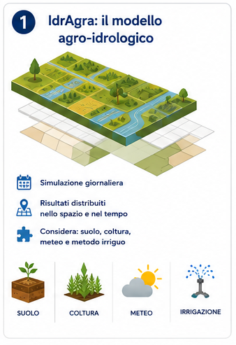
IdrAgra: the model behind the platform
IdrAgra is a semi-empirical model used to estimate the water balance of the soil-crop-atmosphere system and crop irrigation requirements. The model operates on a spatial basis: the study area is divided into calculation units, which may correspond to cells or polygons, and soil, crop, meteorological data, and irrigation method are considered for each unit. The simulation runs on a daily time step and produces results distributed in space and time, which are useful for assessing water requirements, consumption, water stress, soil water fluxes, and expected yields.
Each simulation starts with the definition of a domain, that is, the area over which the calculation is performed. In the model, the domain can be discretized using a regular grid or a vector layer of polygons. In IdrAgraWEB, this process is simplified: the user uploads or defines the fields, and the platform associates each one with the information required for the simulation, such as soil characteristics, crop, irrigation method, and meteorological data.
The spatially distributed approach makes it possible to account for the actual variability of the territory: two nearby fields may have different soils, different crops, or different irrigation conditions and therefore different water requirements. It is therefore advantageous to be able to associate different soil, meteorological, and agronomic characteristics with each spatial element.
The following sections present the four main modules into which the model is organized: crop phenology, soil-crop water balance, irrigation, and yield.
Crop phenology: how crop development is simulated
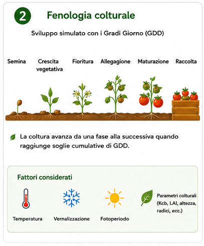
Crop development is simulated using an approach based on Growing Degree Days, or GDD. The model calculates the daily thermal contribution to plant growth based on daily minimum and maximum temperatures. The crop progresses from one phenological stage to the next when it reaches specific cumulative Growing Degree Day thresholds.
For annual crops, the Growing Degree Day count starts at sowing and ends at harvest; for perennial or permanent crops, the season can be considered over the entire year. The sowing date can be determined based on thermal conditions: IdrAgra checks whether, within the sowing window, the average temperature meets the minimum threshold required by the crop.
In addition to temperature, the model can also account for vernalization and photoperiod. This makes it possible to represent crops whose growth or flowering depends on exposure to cold or day length. Crop parameters also describe the evolution of the basal crop coefficient, leaf area index, crop height, and root depth throughout the crop cycle.
Evapotranspiration: from atmospheric demand to crop water use
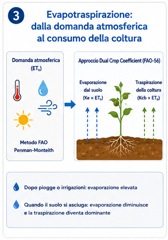
Atmospheric evaporative demand is estimated through reference evapotranspiration, calculated using the FAO Penman-Monteith method. This method uses daily meteorological variables such as temperature, relative humidity, wind, and solar radiation.
Starting from reference evapotranspiration, IdrAgra separates soil evaporation and crop transpiration according to the FAO-56 dual crop coefficient approach. In practical terms, water consumption is not represented by a single crop coefficient, but by distinguishing the basal crop coefficient, related to plant transpiration, and the evaporation coefficient, related to the water present in the surface soil layer.
This distinction is important because it makes it possible to better represent what happens after rainfall or irrigation: when the soil surface is wet, evaporation can be high; when the soil dries out, evaporation decreases and crop transpiration becomes the dominant component of the balance.
Soil water balance
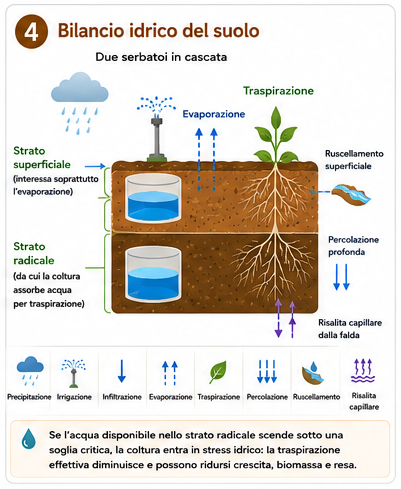
The core of the model is the soil water balance. IdrAgra represents the soil using two main layers: a surface layer, mainly affected by evaporation, and a root-zone layer, from which the crop absorbs water for transpiration. The two layers are modelled as nonlinear reservoirs arranged in cascade.
The water balance includes precipitation, irrigation, infiltration, evaporation, transpiration, percolation, surface runoff, and, where applicable, capillary rise from the water table. The model updates soil water content over time and assesses whether the amount of water available in the root zone is sufficient to meet crop demand.
When available water falls below a critical threshold, the crop may experience water stress. In this case, actual transpiration becomes lower than potential transpiration, and growth, biomass, and yield may be reduced.
Runoff, percolation, and capillary rise
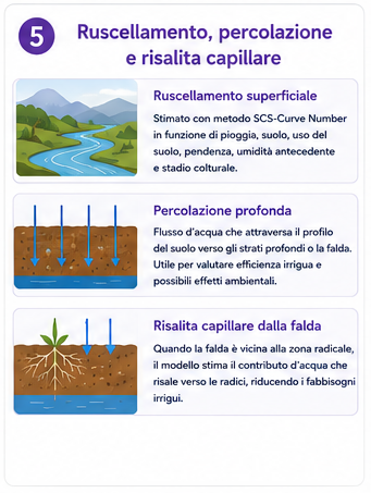
Surface runoff is estimated using the SCS-Curve Number method, which relates runoff generation to rainfall, soil hydrological characteristics, land use, slope, antecedent soil moisture conditions, and crop stage. From the difference between rainfall, surface runoff, and initial losses, the actual volume of water infiltrating into the soil is estimated.
Percolation represents the flow of water through the soil profile towards deeper layers or the water table. This information is useful not only for estimating irrigation efficiency, but also for assessing possible environmental effects of irrigation management.
When the water table is sufficiently close to the root zone, IdrAgra can also simulate capillary rise, that is, the contribution of water moving upwards from below towards the roots. This process can reduce actual irrigation requirements, especially in soils and hydrogeological conditions that favour capillary rise.
Irrigation simulation and estimation of water requirements
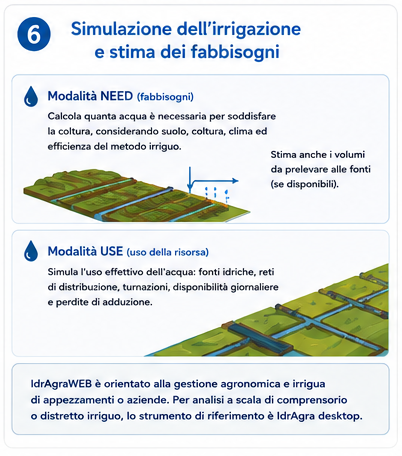
IdrAgra can operate in different modes. The NEED mode is focused on estimating irrigation requirements: the model calculates how much water would be required to meet crop needs, taking into account soil, crop, climate, and irrigation method efficiency. If information on irrigation sources, irrigation units, and conveyance/distribution efficiencies is available, the model can also estimate the volumes that need to be withdrawn from water sources to meet these requirements.
The USE mode, available in the IdrAgra model, is instead designed to simulate the actual use of irrigation resources, including water sources, distribution networks, irrigation schedules, daily availability, and conveyance losses. This mode is particularly useful for studies at the command area, irrigation district, or collective irrigation system scale.
In the current configuration of IdrAgraWEB, the platform is primarily focused on the agronomic and irrigation management of fields or farms, with a guided workflow for estimating water requirements, comparing scenarios, and interpreting results. For detailed analyses of irrigation water source use and resource distribution at the irrigation district or consortium scale, the desktop version of IdrAgra remains the reference tool at present.
Irrigation methods and application efficiency
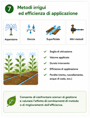
The irrigation method affects how water is applied to the field and the proportion that is actually available to the crop. IdrAgra allows different irrigation methods to be described using parameters such as activation threshold, applied volume, intervention duration, efficiency, and possible losses.
In the case of sprinkler irrigation, for example, losses may also depend on wind and temperature; in the case of surface irrigation methods, losses related to runoff or tailwater can be taken into account. This representation makes it possible to compare different management scenarios, for example by assessing the effect of changing the irrigation method or improving its efficiency.
Yield estimation
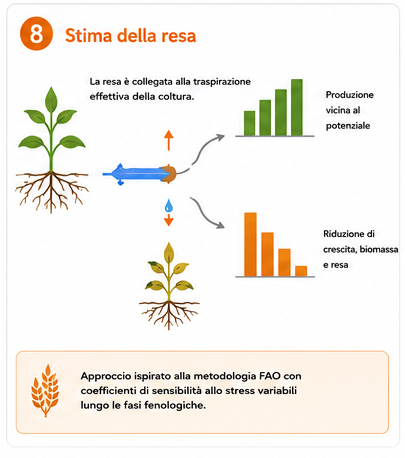
Yield is estimated by linking biomass production to actual crop transpiration. In the absence of stress, the crop can approach its potential production; in the presence of water deficit or heat stress, actual production may decrease. The yield module uses an approach inspired by the FAO methodology, with stress sensitivity coefficients that may vary throughout the phenological stages.
This makes it possible to assess not only “how much water is needed”, but also the potential effects that suboptimal irrigation management may have on production. The results should be interpreted as model-based estimates, useful for comparing scenarios and supporting decisions, rather than as direct measurements of actual production.
Output and interpretation of results
IdrAgra provides results in the form of maps, charts, statistics, and reports. Outputs may include meteorological variables, irrigation requirements, irrigation volumes, evaporation, transpiration, runoff, flows to or from the water table, and estimated yields. IdrAgra also produces a scenario report that provides a summary of the available information, including field context, weather statistics, the spatial distribution of water requirements, the average soil-atmosphere-plant water balance, and estimated production.
The goal is not to replace the experience of technicians or farmers, but to provide quantitative and consistent support for comparing alternatives: different crops, different irrigation methods, different climatic years, or different management scenarios.